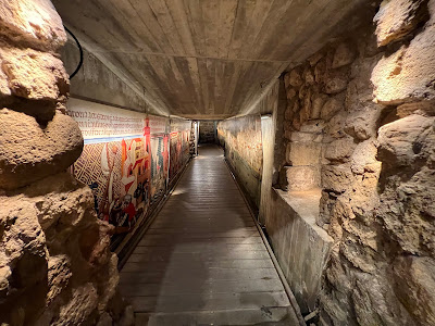
This underground passage linked the Templars’ fortified quarter with Acre’s port during the final century of Crusader rule in Palestine. Known in Arabic as…
This underground passage linked the Templars’ fortified quarter with Acre’s port during the final century of Crusader rule in Palestine. Known in Arabic as نفق فرسان الهيكل, the tunnel runs beneath the southwestern part of Acre’s Old City. It preserves part of the medieval city that lay below the streets and buildings of the later Ottoman town. From the Templar fortress to the port The Templars were a Latin Christian military order established in Jerusalem during the Crusader period. After Salahuddin al-Ayubi liberated Jerusalem in 583 AH/1187, the order transferred its principal base in Palestine to Acre and developed a fortified quarter beside the sea. The passage extended eastward from the Templars’ main fortress toward Acre’s harbour, crossing beneath the medieval Pisan quarter. About 150 metres of the route have been exposed. Its lower section was cut into natural rock, while hewn masonry formed the upper section and its barrel-shaped vault. The liberation of Acre Acre became the chief centre of Crusader power in Palestine after the loss of Jerusalem. The city’s harbour connected its military orders and merchant quarters with ports across the Mediterranean, making passages between the waterfront and fortified compounds strategically valuable. In 690 AH/1291, the Mamluk Sultan al-Ashraf Khalil ibn Qalawun liberated Acre, ending the city’s role as the last major Crusader capital in Palestine. Much of the medieval town was subsequently buried beneath later construction, while the Acre visible today largely reflects the rebuilding undertaken during the Ottoman period. The tunnel was uncovered in 1994. Its western section opened in 1999, and excavation and rehabilitation continued until the exposed route was opened in full in 2007. It is one of the underground structures through which the street plan of Crusader Acre can still be traced beneath the Ottoman city.