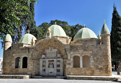
Built in 1815–16, this Ottoman sabil supplied water on the historic road leading east from Jaffa towards Jerusalem. Known in Arabic as سبيل أبو نبوت, it takes…
Built in 1815–16, this Ottoman sabil supplied water on the historic road leading east from Jaffa towards Jerusalem. Known in Arabic as سبيل أبو نبوت, it takes its name from Muhammad Agha Abu Nabbut, governor of Jaffa and Gaza from 1807 to 1818. A sabil was a charitable public fountain, commonly established through a waqf, an endowment created to sustain a religious or civic service. Abu Nabbut’s rebuilding of Jaffa Muhammad Agha Abu Nabbut had served among the mamluks of Ahmad Pasha al-Jazzar before governing Jaffa under Sulayman Pasha of Acre. His rule followed the destruction inflicted on the city during the French campaign of 1799, and his building programme helped restore Jaffa’s fortifications, markets, public institutions and water provision. Abu Nabbut’s waqf, established through several endowments between 1812 and 1816, centred on the Great Mahmoudiya Mosque and its madrasa. It also included two sabils, while income from shops, bazaars and khans supported the endowed buildings. Sabil Abu Nabbut stood beyond the old city on the principal inland route, serving merchants, pilgrims and other wayfarers travelling between Jaffa’s port and Jerusalem. The fountain on the Jerusalem road The structure was built primarily from local kurkar stone, with reused limestone and marble decoration. Three ridged domes cover the building. On its western face, the fountain occupies a broad arched niche framed by white marble columns against red marble panels. Historic photographs record finials above the domes and corner pinnacles that have since disappeared. The openings on several sides were later blocked, altering the building’s original relationship with the road and its water source. The surrounding grounds were redesigned as a public garden in the 20th and 21st centuries, while the sabil preserves the route’s earlier role in carrying travellers from the Palestinian coast towards Jerusalem.