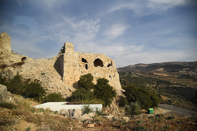
Qal‘at al-Subayba (قلعة الصبيبة), now commonly called Nimrod Fortress, is an Ayyubid stronghold built to guard the route from the Galilee and Banias towards…
Qal‘at al-Subayba (قلعة الصبيبة), now commonly called Nimrod Fortress, is an Ayyubid stronghold built to guard the route from the Galilee and Banias towards Damascus. The fortress stands above Banias on the southern slopes of Jabal al-Shaykh. Its position allowed its garrison to watch the approaches through the northern Jordan Valley and the mountain passes leading eastwards into the heart of al-Sham. The Ayyubid defence of Damascus Al-Malik al-Aziz Uthman, the Ayyubid ruler of Banias and a nephew of Salahuddin al-Ayubi, built the principal fortress between 625 and 627 AH (1228–1230). The work formed part of the preparations against the Sixth Crusade, whose advance threatened the western approaches to Damascus. Arabic building inscriptions preserve al-Aziz Uthman’s connection with the site. The Muslim historian Ibn Kathir also names him as the ruler who built al-Subayba, placing the fortress within the network of Ayyubid castles protecting the cities and roads of al-Sham. Baybars and the Mamluk expansion Mongol forces took Banias and al-Subayba in 658 AH (1260). After the Mamluk victory at Ayn Jalut later that year, Sultan al-Zahir Baybars recovered the region and strengthened the fortress as part of his defence against both renewed Mongol incursions and the remaining Crusader states. Baybars entrusted al-Subayba to his commander Bilik, under whom substantial extensions and repairs were completed. A monumental Arabic inscription dated 674 AH (1275) records this Mamluk work and names Sultan al-Zahir Baybars. The fortress subsequently served as a military and administrative centre before losing its earlier strategic role under Ottoman rule. The name Qal‘at al-Subayba belongs to the fortress’s medieval record, while Qal‘at Nimrud became common at a later date. The surviving Ayyubid and Mamluk inscriptions identify the site most clearly with the Muslim rulers who fortified the road to Damascus.