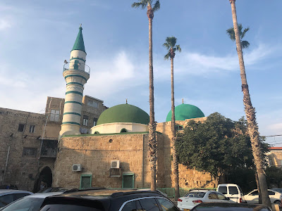
Al-Muallaq Mosque, known in Arabic as المسجد المعلّق and also as the Mosque of Zahir al-Umar, belongs to the rebuilding of Acre under the eighteenth-century…
Al-Muallaq Mosque, known in Arabic as المسجد المعلّق and also as the Mosque of Zahir al-Umar, belongs to the rebuilding of Acre under the eighteenth-century Palestinian ruler Zahir al-Umar al-Zaydani. It was established during his rule by Shaykh Suhayl, whose death is dated to 1161 AH/1748 CE. The mosque occupies an elevated site above the commercial streets of the Old City, giving rise to the name al-Muallaq, “the suspended” or “hanging” mosque. It stands north of Khan al-Umdan, near the end of the old public market and close to Acre’s historic harbour quarter. A mosque from Zahir al-Umar’s Acre Zahir al-Umar governed an autonomous domain in northern Ottoman Palestine and made Acre the centre of his rule. The city’s port, markets and fortifications were developed during this period, restoring Acre as a major commercial centre on the eastern Mediterranean coast. Al-Muallaq Mosque formed part of this renewed urban life. The site had previously served Acre’s Jewish community as a synagogue. Under Zahir al-Umar it became a mosque, while another building was provided for the community’s synagogue. The mosque’s association with his rule gave it its second name, the Mosque of Zahir al-Umar. The elevated prayer hall The prayer hall is reached from street level by a stairway leading into its courtyard. Its raised position above the market distinguishes it from Acre’s other historic mosques. The building once had a minaret; only its lower base survives after the upper section was removed during the twentieth century.